Sunday, 15 April 2012

West Highland Way: Day 3


Date: Tuesday 3 April

Route: Balmaha to Rowardennan

Distance: 7 miles

Accommodation: Rowardennan Hotel

Another relatively short walking day, virtually all of it alongside the south-eastern side of Loch Lomond, and the way in which the guidebook describes the lack of major climbs makes us wonder if we would have been better to have lost a day’s walking and tackled the whole 14/15 mile route from Drymen to Rowardennan in one go.

In the event, we wake to snow (although nothing as bad as the blizzard conditions that have hit further south, thankfully!) and the opportunity to take a slow wander along a much less populated path than we have been used to so far, which still has enough climbs and descents to make us grateful that it wasn’t tacked on at the end of another 7 miles!

Balmaha, where we stayed the night, is home to the Oak Tree Inn (not wildly exciting but obviously used to dealing with large quantities of visitors efficiently), a boatyard that runs ferries and pleasure cruises across Loch Lomond (though no cruises in early April), a big car park and a small but friendly shop.

As we leave, the snow on the mountain tops adds a new dimension to the walk and the views, although some of the snowy hillsides resolutely refuse to show up on camera, blending in with the cloudy sky and disappearing from the photographic record.

The day’s walking, although at times close to the (currently) quiet road between Balmaha and Rowardennan, for the most part alternates between attractive forests (including the Ben Lomond National Memorial Park) and deserted loch-side beaches along the southern side of Loch Lomund. There are a few sections to get your heart pumping and a few hillsides where great views appear, seemingly out of nowhere, making this a lovely section of the walk, once again very easy to follow.

West Highland Way: Day 2


Date: Monday 2 April

Route: Drymen to Balmaha

Distance: 7 miles

Accommodation: Ashbank B&B, Drymen

When we were planning this trip ages ago, we could choose to complete the route in anything from 5 days to 10 days walking. Even though we do more than our fair share of walking at weekends and on holidays, we have only ever done day walks before, with the option of wussing out for a day if the weather gets too atrocious!

Given that the West Highland Way is our first long-distance path walked linearly and on consecutive days, we decided to go for a leisurely option i.e. average 9.5 miles per day and only one 14-mile day during the course of the week, so we had the interesting experience today of completing a relatively short section of the Way (7 miles), whilst many of the people who had set off from Drymen at a similar time were powering off to cover another 7 miles. We’re hopeful that this means that the number of people walking the same section of the route will decrease slightly, as we won’t be part of a huge crowd who all are starting and ending together.

As we had only 7 miles to cover, we had time to enjoy a great cooked breakfast courtesy of Tommy at the Ashbank B&B, a comfortable place to stay in the centre of the village and very close to the welcoming Potters pub (“Best” bitter, veg curry and pizza all highly recommended!).

The route was very busy leaving the village, but soon headed up into the woods and the number of walkers became more spread out. This first section was a stark reminder that forestry is very much an industry in these parts – whilst the guide book made reference to Garadhan Forest, planted in the 1930’s and pleasant, sheltered walking through a monoculture of pine trees, the reality today was of a wide exposed road, obviously well-used by timber trucks, with woodpiles on either verge and a hillside looking as though it had been ravaged to create weaponry for an army of Orcs. Obviously, from a more positive perspective, the forestry brings much-needed income – and walkers benefit from long-distance views across to Loch Lomond - but I suspect it will all look better in a few years when some of the new plantations are at a more advanced stage and wildlife has returned to the bare hillside.

The path heads steadily and stealthily upwards, so is not unduly exerting and only really turns into a proper climb once you have crossed a footbridge and started climbing 170m, winding your way around Conic Hill (also referred to as Conich Hill on some signs). The West Highland Way does not include the detour to the top of the hill but given that it only takes a few minutes it is definitely worth the (steep) effort for some great views across the southern end of Loch Lomond and to the row of islands in the loch which mark the fault zone of the Highland Boundary Fault, the geological fracture which separates the Lowlands from the Highlands.

From the top of the hill, the path starts to descend again and, after passing a grassy bank with more fantastic views across the loch, becomes easy again, heads into pine woods and exits the woods into a car park and on to the loch-side and the welcome sight of the Oak Tree Inn.

West Highland Way: Day 1


Date: 1st April 2012

Route: Milngavie to Drymen

Distance: 12 miles

Accommodation: Premier Inn, Milngavie

After three months of walking nearly every weekend, trying to eat relatively healthily and hoping that all of this exercise would mean we were fit enough to walk the 95-mile West Highland Way, we finally took our first steps along the route today, on the initial section from Milngavie (pronounced Mullguy) to Drymen (pronounced Drimmen). Just as well that we were following the West Highland way route, as detailed in the Trailblazer Guide and didn’t have to ask anyone for directions!

If our breakfast porridge was anything to go by, Scotland really is the land of milk of honey, and we set out suitably fortified on a glorious spring morning, without a cloud in the sky, leaving Milngavie’s shopping precinct and the unmissable obelisk, gate and benches marking the start of the West Highland Way to quickly join an excellently signposted, fantastically maintained path out of Milngavie and up through woodlands.

The first section of the walk takes you out of Milgavie relatively quickly, with the stream of Allander Water away to your left and leads up to a hilltop with views back over the town and to distant hills. From there it is into Mugdock Wood, alongside Craigallian and Carbeth Lochs – with stunning views of Dumgoyne appearing almost out of nowhere - then past the wooded hump of Dumgoyach before joining the route of the old Blane Valley Railway for 4 miles of straight, flat and admittedly not very exciting walking (although the whisky distillery en route might prove a suitable distraction for those in search of more excitement).

The Beech Tree Inn in Dumgoyne sells pub grub or lets you eat your own food there, but to get there at lunchtime you probably wouldn’t need to leave Milngavie until 10am – we were there too early to really take advantage of their facilities. After the slightly less picturesque sight of the nearby sewage works and some enterprising kids who had set up their own snack stand selling cakes alongside the path, we arrived in the hamlet of Gartness, basically a row of cottages next to the road bridge crossing the weir at Endrick Water.

From this point on to Drymen, the route follows a quiet road, with some gentle climbs rewarded by great views across the hillsides – including Conic (or Conich?) Hill, the big climb of tomorrow - and our first views of Loch Lomond.

So, 12 miles down, only 83 to go! After a straightforward start to the walk in better-than-expected sunshine, we have a few days of relatively short distances and Loch Lomond to look forward to, before the hills really start to dominate. Can’t wait…

Sunday, 25 March 2012

Cookham Circular - in search of The Bounty


Date: Sunday 25th March 2012
Route: Cookham Circular via Bisham Wood, Winter Hill and the Thames Path
Distance: 7 miles

For our last walk before we head off to Scotland and along the 95-mile West Highland Way, we chose a relatively easy, favourite route - and were lucky enough to have yet another beautiful sunny day to walk on.

The walk comes from the first Time Out Book of Country Walks and is described (in more wintry circumstances) in this previous blog post. Luckily, the latest version of the book doesn't bother with the side-trip to Bisham (which just seemed to entail crossing a busy road), although there is an extension proposed along to Boulter's Lock and Maidenhead, which could be good if you're on the train and not driving.

The first section of the walk is through Cookham, past the house where artist Stanley Spencer worked, up a gentle hillside of brassicas and into Bisham Wood, where a broad bridleway follows the edge of the escarpment, with the Thames and great views of Marlow down to the left.

Once out of the woods the views get even better, from Winter Hill, home of Kenneth Grahame, author of The Wind in the Willows. The path descends slowly towards the Thames, which you then follow all the way back to Cookham, with Spade Oak (home to a great pub and Enid Blyton) visible on the other side of the river and the fantastic Bounty pub an essential stopping-off point en route.

The Bounty is one of our favourite pubs encountered in the course of walking - as well as actively encouraging walkers, dog-owners and families, there are plenty of tables outside which are always packed on a sunny day, a great selection of beers from the nearby Rebellion brewery, generous/ hefty portions of food and an eclectic and entertaining music policy. The only way to get to the pub is by foot or by boat but it is well worth the effort.

This walk is straightforward and not overly strenuous, includes beautiful views, an easy riverside path and a fantastic pub - doesn't get much better than this, this close to London!

PS no, I'm not sure about why there is a wigwam in the woods either - looks good though!

Saturday, 24 March 2012

Walking near Dorking - vines, views and Polesden Lacey


Date: Saturday 24th March 2012
Route: Box Hill & Westhumble Circular via Polesden Lacey
Distance: 7.5 miles

Although we walked this route (no. 14 in the Time Out Book of Country Walks Volume 2) five years ago, I had little more than a hazy memory of a good walk with a big section through a vineyard when we set off today.

It was great to discover that this is a beautiful walk, with at least three really picturesque places to stop and picnic on a sunny day. Also worth noting that it's a lot easier to drive there on the M25 rather than going through Kingston etc and getting stuck in traffic (definitely one to remember next time!).

The walk starts off from Box Hill & Westhumble station, with views of Box Hill dominating the first part of the walk. As well as playing a big part in Jane Austen's Emma, Box Hill will be in the news this summer when the Olympic Cycling Road Race will take place there. 

The path crosses the National Trust's Chapel Farm Fields, across fields and up a track through woods past the idyllically situated Tanners Hatch Youth Hostel, then on to a hilltop with the first view of historic house Polesden Lacey across the valley. The house on the hillside boasts great views across the countryside and was home to many glamorous house parties in the early 1900's.

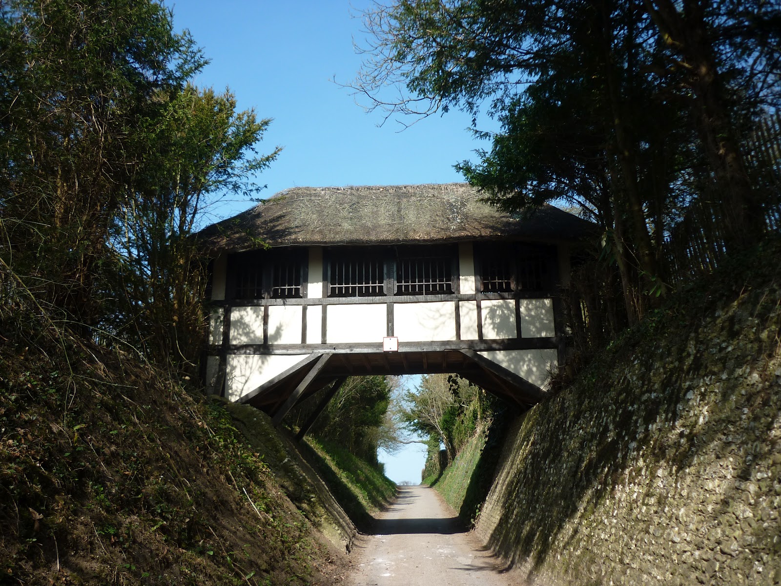
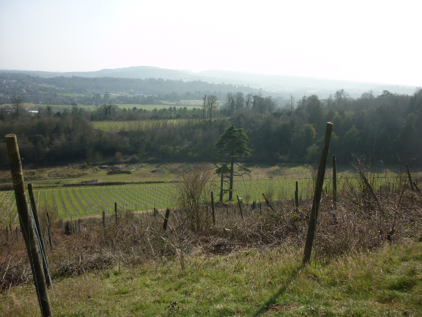
From the hilltop the path descends towards the house, passing under a wooden bridge and a more impressive thatched bridge (see photo). Leaving the house behind, the path heads back into woodland, passing along a yew-lined road and eventually emerging into the open Steers Field, a beautiful hillside with views down over Dorking, the surrounding countryside and even to the South Downs (on a clearer day than today).

Most of the remainder of the walk is on the easy-to-follow North Downs Way, passing the solid church of St Barnabas, Ranmore before entering the Denbies Wine Estate, the biggest vineyard in England, with vines covering the hillsides and a Visitor Centre and tearoom,

I would love to do this walk again in a few weeks' time when the bluebells are all out and it will be even more attractive, but I would recommend this walk at any time of year and look forward to walking it again, whatever the time of year. 


Sunday, 11 March 2012

Henley in the sunshine


Date: Sunday 11th March 2012
Route: Hambleden to Henley then back along the Thames and over Medmenham Lock
Distance: 9.8 miles

Since this a walk that I've blogged about a couple of times (and walked so often that we don't even look at the directions in the Time Out Book of Country Walks Volume 1 any more!), there isn't much to say about today that hasn't been said before.

Previous blog entries are at http://stileguru.blogspot.com/2012/01/first-walk-of-2012-ouch-henley-and.html and http://stileguru.blogspot.com/2011/01/walk-1-hambleden-circular-via-henley.html

A beautiful walk on a beautiful day - very difficult to think of a better way to spend a sunny Sunday.

Saturday, 10 March 2012

Wycombe Wanderers


Date: Saturday 10th March 2012
Route: Saunderton Circular via West Wycombe
Distance: 9.9 miles

This walk isn't for anyone who is deterred by hills or mud, but it is one that we keep coming back to, as it has a lot going for it - just the right amount of fields, hillsides and woodland, some interesting sights (Disraeli's house Hughenden Manor, the Dashwood Mausoleum and the Hellfire Caves), a good lunch stop and great views across the countryside.

This is the 3rd walk from the Time Out Book of Country Walks Volume 2 and starts off from the station at Saunderton, on the road between High Wycombe and Princes Risborough. The initial section is across and alongside fields and very popular with ramblers and dog walkers.

After passing Bradenham Manor the route leads you uphill into the first of many woodland sections and follows an easy grassy path through trees. Once past the houses on the outskirts of Naphill, it's more woodland, this time on a bridleway that is the muddiest section of the walk (see photo above!). We've done this walk a few times and it has only been dry underfoot once (later in the year).

There is more (less muddy) woodland to follow, crossing Flagmore Wood and Woodcock Wood, to arrive at the car park for Hughenden Manor. This National Trust property is the former home of Benjamin Disraeli and has its own second-hand bookshop, as well as a cafe serving good food made from locally sourced ingredients, with seating both inside and in the courtyard (definitely a nice place to take a break on a sunny day).

After lunch the walk continues through more woodland and then across rolling hillsides with great views across to the Dashwood Mausoleum on the hillside, which provides the last climb of the walk. From the Mausoleum there is a straight and easy-to-follow downhill path back through wooded areas and along the road back into Saunderton.

Although we started walking in a slight mist, the sun broke through and made this one of the finest walking days of the year. With lots of bird life, including skylarks, partridges, pheasants and (unseen but definitely audible) woodpeckers, plus squirrels and even a tiny mouse curled up on the path, it definitely felt as though spring was in the air.

A highly recommended walk (though possibly with a pair of gaiters unless you want to end up with very muddy trousers!).