walking, rambling and getting lost in the countryside - I'm walking the walk, so that you don't have to
Sunday, 26 February 2012
The Chess Valley
Date: Sunday 26th February
Route: Latimer Circular through woodlands and villages of the Chess Valley
Distance: 9.5 miles
As we do rather a lot of wandering around the Chilterns and Thames Valley, it's not often that we discover a walk that he haven't at least partially completed previously - finding a wholly unknown route and tackling it in brilliant sunshine made today one of the best walking days of the year so far.
The walk comes from the Pathfinder Guide and sets off from a free car park on the road between Little Chalfont and Latimer. It is a winning combination of pretty, Miss Marple-esque villages (with a much higher pub count than usual), manor houses, woodlands, hillside views and riverside walking. The area is popular with walkers, cyclists and horse-riders, but is surprisingly quiet, given how easy it is to access it from London.
The start of the walk sees you crossing the river Chess and passing through the village of Latimer before heading up onto the first, very chalky, wooded hillside and the first great views over the valley. The very straightforward path then heads out of the woods, between hedges and into the village of Flaunden, whose church is visible from a distance. More easy paths and wooded areas follow - although there are a few ascents and descents to contend with, these are not too strenuous.
After the popular path alongside Chipperfield Common, the Cart & Horses pub at Commonwood is a welcoming place to stop for food or drink - and today it was even warm enough to sit in their large garden - before continuing on to the village of Sarratt (with another picturesque pub and a church that appeared in "Four Weddings and a Funeral") and the path across fields and over the hillside to Church End.
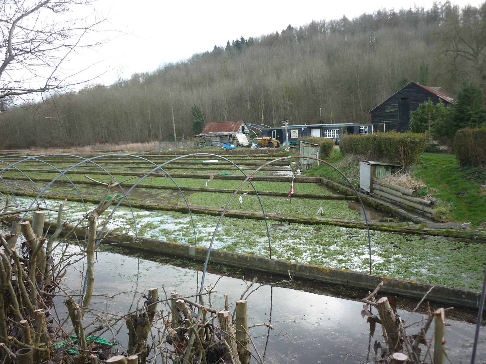
Yet more lovely views and a tree-lined path lead back downhill and to the river Chess, then the next section of the walk follows the Chess Valley Walk on a well-maintained and busy path. The river Chess provides the perfect growing conditions for watercress and you can see the watercress beds alongside the path.
Once over the river and through more woods, the last ascent of the walk is into the village of Chenies, which boasts an impressive Tudor manor house (open to visit in the summer), with fantastic twisted chimneys, before the path leads back to the car park, with yet more great valley views and woods en route.
This is a highly recommended walk which I'm sure we will repeat time and again.
Sunday, 19 February 2012
Muddy Maidenhead, Cookham and Cliveden Reach
Date: Sunday 19th February 2012
Route: Maidenhead to Cookham and back along the Thames Path
Distance: 5.5 miles
As previously noted, when a walk starts by going through a housing estate, it's not usually a good sign - and when a gravel works, a football pitch and a very muddy field filled with slightly whiffy brassicas are the next few things you encounter, your heart sinks. Luckily this walk redeems itself at the end, with a 1.5 mile section along the Thames.
The walk comes from the Pathfinder Chilterns & Thames Valley book (walk 7, Wildbrook Common and Cliveden Reach) and is all very flat. It starts from the car park at Boulter's Lock but only really starts getting interesting once you are a bit further away from civilsation, crossing the National Trust's Wildbrook Common, with views across the fields to Cliveden, the imposing house on the hillside that belonged to the Astors and was associated with the Profumo scandal.
There is a pretty section of path alongside Strand Water, then a covered path leads into the village of Cookham, home of Stanley Spencer and the Chartered Institute of Marketing. A lane leads away from the village and down to the Thames near Cliveden, then all the way back to the car park.
Saturday, 18 February 2012
Wet wanderings near Marlow
Date: Saturday 18th February
Route: Hambleden to Marlow and back along the Thames
Distance: 12.1 miles
After a few weekends of frosty days with clear blue skies and ominous grey skies that have threatened rain but not quite delivered, it was inevitable that we would encounter a proper downpour at some point - and that point was today. Given that we're preparing to walk the West Highland Way, arguably we need to be prepared for rain!
Luckily we didn't have the full twelve miles of walking in the rain, just six (from Marlow back to Hambleden). This is the Marlow walk from the Time Out Book Of Country Walks Volume 2, but given that the Stag & Huntsman in Hambleden is a building site at the minute, parking up in the free car park on the road to Hambleden and starting and ending the walk there is a better option - not only do you have lots of pubs and restaurants to choose from as your lunch stop in Marlow, you also get to do the steepest bit of the walk first, heading up to the woods behind Hambleden.
This is a straightforward walk, which we have done a few times (so much so that the guide book was one of the few things to stay dry in my bag for most of the walk), combining a few hills, lots of woodland, locks, picturesque villages and a nice long stretch of Thames Path. Even in the rain it is still highly recommended (although if you want to see some slightly nicer photos and a bit more detail about the walk, check out this previous blog entry).
Note to self: don't leave your waterproof trousers at home next time though!
Saturday, 11 February 2012
Wendover Winter Wonderland
Date: Saturday 11th February
Route: Wendover Circular through woodland to Pulpit Hill Fort, Beacon Hill, Ellesborough and back
Distance: 8.4 miles
With clear blue skies and brilliant sunshine, it was impossible to use the snow or cold weather as an excuse not to walk, although when we arrived at Wendover and found that the snowfall was slightly deeper than in Ealing we did worry that we might not actually be able to see the paths! Luckily this wasn't the case and whilst the going was a bit heavier than usual, this was a fantastic way to pass a sunny winter Saturday.
The walk sets off from Wendover station, heading up over the hillsides and very quickly into beautiful woods, with the snow adding a Narnia-esque feel to the whole proceedings. This is the first walk in the Time Out Country Walks Volume 2 book and is very easy to follow, with clear paths (and lots of footprints and paw prints today!). After taking the short cut across fields and along a bridleway, there is a climb up into Pulpit Wood and a wide, well-signposted track to the remains of Pulpit Hill Fort.
Once past the hill fort the path follows the edge of the wood, before emerging onto the hilltops near Chequers, then heads back into woods and onwards towards the imposing Beacon Hill, which was a magnet for sledgers today. Once past the hill, the pretty church at Ellesborough comes into view and the path descends through the churchyard and alongside fields, with lovely views back to Beacon Hill and up to the Boer War monument at Coombe Hill up to the right. After a few sheep-filled fields, the path descends through a farm then crosses fields to get back to Wendover.
Whilst this wasn't the easiest of weather in which to do this walk it was well worth the effort - a highly recommended, wonderfully wintry, West Highland Way woodland warm-up from Wendover.
Sunday, 29 January 2012
A hard walk out of Henley - Stonor, Pishill and back
Date: Saturday 28th January
Route: Henley to Stonor and Pishill and back
Distance: 13.7 miles
Last weekend, we did a long flat walk and a short hilly one. This weekend, our walk was both long and hilly - and exhausting - but still one of the best walks we have done for a while and well worth a try if you don't mind 5 hours of walking in the beautiful countryside near Henley.
Whilst the walk starts and ends in Henley, it doesn't take long to get out of town and into the countryside, following the Oxfordshire Way into the Chiltern Hills, rising quickly onto the hillsides, then descending into the village of Middle Assendon, home of the Rainbow Inn. As the full version of the walk is nearly 14 miles long (one of the longest in the Time Out Book of Country Walks, Volume 2), it is possible to turn off here, following the signs to Bix Bottom, for a shorter (8.8 mile) version, which we have walked a few times, and which includes a lot of quiet country roads (see summary here).
Mindful of the fact that we will have to face a very hilly 14 miles on the last leg of the West Highland Way, we ignored the turning off and carried on along the road, and very quickly uphill, to a fantastic path along a ridge at the top of the valley, with the road far below us and fantastic views of the rolling Chiltern Hills away to the left. This path leads eventually into the village of Stonor, complete with deer park, and on further still to the village of Pishill, where The Crown is a great lunch stop, complete with roaring fire and friendly staff.
The return journey starts off with a climb, but quickly rejoins the Oxfordshire Way and becomes an easy path through pheasant- and partridge-filled woodland, emerging through fields at the ruined church of St James, mentioned in the Domesday Book but abandoned in the 1870's, then heading through a farmyard, uphill and back into more woods, eventually emerging at a golf course, the razor-wired fence of George Harrison's old house and gently downhill into Henley.
This is a fantastic walk - though the distance and the amount of hills means that it won't necessarily appeal to everyone. The views from the ridge do really justify the effort and you can enjoy the peace and quiet of very quiet paths, with red kites wheeling overhead.
Sunday, 22 January 2012
Ivinghoe Beacon and the Ashridge Estate
Date: Sunday January 22nd
Route: Tring Station to Ivinghoe Beacon, through Ashridge Estate to Bridgewater Monument and back via Aldbury
Distance: 8.3 miles
The last time we did this walk, I seem to remember ice cream being a feature - today, the key feature was very blustery wind. It doesn't seem to matter which time of year we do this walk, it is always a great one to do - and it certainly blew the cobwebs away today!
After yesterday's flat, linear city walk, we wanted something hillier and more challenging and so we opted for an old favourite walk, to Ivinghoe Beacon. This walk features in a number of different walk books - including the Rough Guide, the Pathfinder Guide and 100 Greatest Walks in Britain - but we did the short version from the Time Out Book of Country Walks Volume 2.
It is a very easy walk to follow - and quite difficult to get lost. The first section all follows the Ridgeway Path, starting off in woodland but soon emerging on to the exposed chalky hillsides. There is quite a bit of steady climbing, with a final heart-pounding steep climb up to the Beacon, the start of the Ridgeway and popular with walkers, runners, mountain bikers, kite-fliers and model aircraft enthusiasts.
The second section is much more sheltered, following a well-maintained and popular path through the beech woods of the National Trust Ashridge Estate, all the way to the Bridgewater Monument, the memorial to the canal builder, who is buried nearby. Apparently the woods feature in films including Sleepy Hollow and Harry Potter & The Goblet Of Fire. From hereon in, the paths are all either flat or downhill.
The cafe at the monument does hot drinks, sandwiches and outrageously enormous cream scones (very tempting, but we didn't succumb!).
The final section leads downhill into the very picturesque, pond-centric village of Aldbury, complete with pubs and a shop, before returning through fields to the station.
A really lovely walk, no matter what time of year you do it.
Clocking up the miles: Ealing to Mile End
Date: Saturday January 21st
Route: West Ealing Station to Matt's Gallery, Mile End and Mile End Station
Distance: 14 miles
One of the challenges that we're going to face on the West Highland Way is the last day's walking (assuming we get that far!), which will be 14 miles. Another challenge that we face when we're walking both days each weekend is that things that we would normally do at weekends can get neglected.
When we heard about a Roy Harper art exhibition at Matt's Gallery in East London, the only way that we could foresee to build it into our weekend schedule was to walk there - so that's what we did. And, by happy coincidence, our route took us on a 14-mile walk.
Obviously we will are going to encounter more hills in the Highlands than in Central London, but this was a good way of checking that we can actually walk 14 miles - and also had the advantage of being pretty much in a straight line from our house, frequently dovetailing with the Central Line, and on mainly flat tarmac pavements and paths all the way.
As we live near West Ealing station, the first part of the walk was our usual 0.7 mile stroll down to Ealing Broadway, before crossing Haven Green to the station, then turning onto the Uxbridge Road, to take us past more greenery at Ealing Common, over the North Circular Road and on into Acton.
Acton is not the most picturesque area of West London (though it too has parks and green spaces) but it is one of those places that reminds you of how diverse London is, with Jamaican butchers selling goat's meat next door to Chinese takeaways, Persian restaurants, Japanese hairdressers, Irish pubs, Australian pubs and grocery stores with fruit and veg from all over the world out front to entice you in.
Further along the Uxbridge Road and Acton turns into Shepherd's Bush, complete with its market, another green (at one point the home of the sheep that the shepherds looked after) and Westfield, a mammoth shopping centre that draws people in from miles around (and has resulted in the loss of many household names from Ealing Broadway Shopping Centre).
If you can ignore the lure of Westfield, it's over the roundabout to well-heeled Holland Park, up the hill into Notting Hill, past the crowds waiting for friends at Notting Hill Gate station and straight on along the road. If you want to get away from the traffic for a while, you can cross the road into Kensington Gardens and follow the path that runs parallel with the road all the way through Hyde Park as far as Marble Arch. From Marble Arch onwards, the population count increases dramatically (as does the amount of road closures) as the road turns into Oxford Street. Past Selfridges and the flagship department stores and over Oxford Circus, the road continues (and your walking has to slow down to accommodate all the shoppers around you), taking in the great gig venue, The 100 Club, the boarded up former Virgin Megastore and lots of work for the forthcoming Crossrail project, with the Centrepoint building as an unmissable landmark.
From there you're in British Museum country, heading down New Oxford Street (and the beautifully distinguished walking stick and umbrella shop) and onwards to Holborn, which suddenly reminds you that it is quite elevated, once you cross Holborn Viaduct. At this point distinctive city landmarks like the NatWest Tower and the Swiss Re ("gherkin") building start to dominate the skyline, juxtaposed with cranes and historic churches. The further into the City of London you get, the less shops and cafes are open at weekends, but the more likely you are to catch tantalising glimpses of imposing buildings like the Old Bailey, the Bank of England, the Royal Exchange and St Paul's Cathedral.
And then you find that you are leaving the impressive architecture and banking headquarters behind you as you leave the City and are officially "out East", within the sound of Bow Bells. Once again there is a dazzling juxtaposition of shops selling produce and goods to cater for a whole host of different communities, as well as the Whitechapel Art Gallery, market stalls and a real mixture of old and new buildings.
The final stretch of the walk took us down Stepney Green (probably the 5th or 6th green of the day!) and over the canal into Mile End and to the gallery, which, of course, was closed (!). So we carried on through the park, past a keenly contested hockey match and finished the walk with a well-deserved pint.
If this walk proves anything, it's that you don't necessarily always need to follow a guidebook - you can just go outside your front door and start walking - and in London, it's a safe bet that you will come across lots of interesting stuff, areas with their own distinctive characters, more greenery than you might think, well-known landmarks and tiny details that you would miss if you were in a car or on public transport.
Subscribe to:
Posts (Atom)